Lower Columbia River Destinations
|
Lower Columbia River Destinations
|
|
The Lower Columbia River Destinations Guide is a non-commercial project of Ralph E. Ahseln and as such is not meant to be substituted for proper navigation charts or the practice of prudent seamanlike skills .
Using this guide is to be at the readers risk. Always practice SAFE Boating procedures.
Questions or Comments should be directed to:
Ralph E. Ahseln
(Please contact the author if you wish extra copies.
The Lower Columbia River Destination Guide conceived by Ralph E. Ahseln May 2007. |
Lower Columbia River Destinations From Portland ORNote ! There are NO marinas between the Vancouver RR bridge and St Helens Oregon..
You can anchor in UNPROTECTED waters .. subject to high wind and wave action..
Caution!!: Avoid Shallows: Oregon side river mile 92 ("Nude Beach") ..And Bachelor Shoals .Washington side river mile 90 to Lewis River mouth. Further Note: Downriver from St Helens OR to Skamakawa WA.. One MAY anchor in many locations BUT, nearly ALL will be subject to High winds and Wave action. Use EXTREME caution and observe weather and traffic conditions. From below Skamakawa WA (river mile, 33) to the Columbia River Bar , It is NOT PRUDENT TO ANCHOR along the LOWER river channel !! Exception MAY be Three Tree and Jim Crow areas.. BUT, use extreme caution in these locations as well !
Fuel available in the Portland area.
All Mileages Approximate.
Nautical Mile distances from I-5 Bridge... in Green.
1 |
|
1.
Tie-up Bull Rails, NO Facilities
2.
Anchorage Only, No Facilities, No Access to land.
3.
Tie-Up Bull Rails. Public restrooms and free showers nearby.
4. Tie-Up Bull Rails. Pit toilets, NO showers. Picnic tables and BarBQ grills nearby. Modern concretefloats. All spots subject to agressive Wind and Wave action. Short walk to primitive sandy island. Trails and woods.
5.
Anchorage ONLY, No Access to land. No facilities.
6.
Off channel , Basin. Long time Boaters favorite "hangout". 2 |
|
7.
Up river end of Sandy Island. Locals favorite anchorage. Large Sand island
8.
Total protection from winds and waves. Inside at end of local moorages.
9. "Funky" marina. Trashy, Limited space. Nothing to recommend it.. Small store across the road.
10. Up river entrance. Good "bailout" anchorage. Muddy sand bottom. Not very pretty and somewhat close to freeway.
11.
New dockage. Inside tie-up Highly recommended. Outside VERY bumpy.
12.
The JEWEL of the river. Parklike, Quiet, Protected. Mid-Point on river Portland to Astoria.
Turn at river buoy and motor back into area behind (West) of island. Difficult to see, but keep going. A floating dock is maintained by Col. River Yacht Club who allows any boater to use it as long as club is not using. Anchorage is easy, but Current is very strong here. DO NOT CUT between land and buoy! Proceed Center channel to dock. 3 |
|
13.
Enter ONLY downriver of Hump Island, Give the North end (downriver) land a WIDE berth. Stay LEFT center all the way. Anchoring behind Hump is open to NW weather. Inside Fisher Island is the Longview Yacht club. Possible tie-up, Limited anchoring. NO facilities. Very long way to town (car).
14. The other side of the river. Not recommended except for a short visit . Enter upriver of the Wing Dam with day mark RED 6 Watch your depth ! Open to all weather. Shallow areas. View is wonderful.. Mt St Helens and surrounding lands. Dinghy access to many long clean beaches. Great place for a picnic on the beach.
15. Do Not try this one unless you have a very accurate Depth Sounder. EXTREMELY difficult to get into. Some people like it.. Personally, Its NOT worth the effort.. Nothing to recommend it except its isolation.
16.
Charming little Island with some beaches and mossy flatland.
17.
New dockage. Inside tie-up Highly recommended. Outside VERY bumpy.
4 |
|
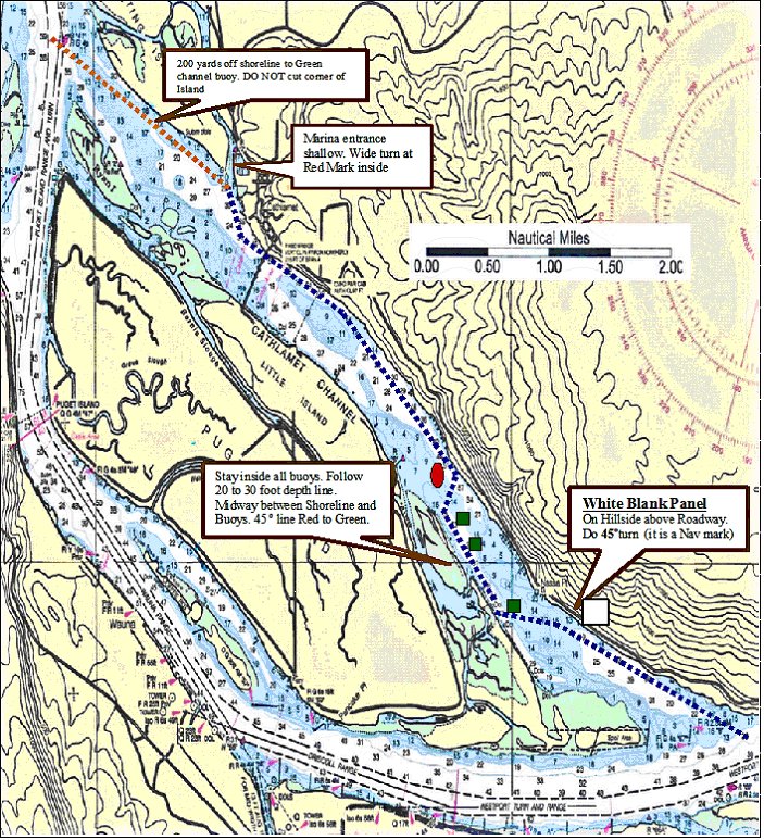
Traveling the Island side, Stay midway between Green buoys and Shoreline ! Its safe . 20/30 feet deep. The entrance to Elochoman Marina (Cathlamet) is very shallow at low tide. Going in, favor the Right Center course. Turn WIDE at Red mark inside (rock underwater close to mark). If at the Downriver end of Puget Island .. Extreme caution ! Do Not attempt to Cut the corner. 5 |
|
18.
If approaching from Upstream, May travel through Cathlamet Channel. Follow Nav marks CAREFULLY!
See attached chart !
19. Pretty area and entrance to the Pairie Channel . Somewhat protected from the NW winds. Enter at Day Mark RED "44". Watch depth, Muddy sand bottom. Dinghy access to many clean beaches. Isolated, quiet. NO facilities.
20.
Lovely tidal meander river. Off river weather protected, Isolated, quiet, some wildlife. 21. !! ? Three Trees Point... WA... ? Jim Crow Point... WA ... 63.0 NM - River Mile 29
CAUTION ! These areas Untested ! Subject to large Tidal Ranges.. Use extreme caution!
22. A"man-made" basin OFF of the main river channel. Good anchorage. Protected from the On-Shore winds and waves. Liked by many because of its Isolation and quiet. Enter at East end of Tongue Point Buoy RED "44" Can experience large Tidal ranges. Use correct anchoring SCOPE for tidal range No facilities.
6 |
|
NOTE ! The PROPOSED Office building is now in operation. The Fuel Dock is below the office ramp ROW E. The Showers and Restrooms at the ramp ends of Rows A and B are being closed. New Restrooms and Showers at building above Row E. There is NO restaurant in the Red Lion building. Guest moorage is at outer end of Rows B and C. Payments are made at the office above Row E.
7 |
|
23.
Protected Moorage part of the Astoria Port Authority. Primarily for Commercial Vessels. A possible ONLY if you clear it with Astoria Port. No facilities. Long walk to town.
24. The Destination Moorage for pleasure vessels. Incoming from the Columbia River bar and downriver cruisers . Visitors moor on the outer end of B and C rows . Marina office is at the top of the E ramp. Moderate cost by vessel length. New Showers and Restrooms. Center of town is 3 or 4 miles away. Sometime serviced by a Free (donation) Trolley car/train, weather permitting. Trolley Terminal is in front of Red Lion Motor Inn. Astoria is a charming city with many Victorian homes and several museums. Excellent restaurants and lounges. A large Marine supply store and repair facilities. Taxi service is available.
Marina does NOT take reservations unless its a large group. The Marina is very near to, almost under the Astoria Bridge. Enter at High Steel Wall. A Blind entry. The Entrance is a bit frightening. However, it is easy to navigate.
Watch for outgoing vessels rigging above the high metal wall. Large fishing vessels also use marina. Enter at moderate speed from the UP-RIVER side. Power through the opening. Entrance subject to very fast current flow during both Ebb and Flood. Standing waves at entrance can be intimidating. Passage Best made at slack tides. Afternoon winds can get high and waves will build. If possible be there before Noon. ON leaving, proceed slowly, check for Incoming traffic, Then POWER out of the entry and make a rapid Angled LEFT transit. Be prepared for a fast flowing current. If on EBB, Move away from the shoreline as quickly as you can. Current can SET you rapidly Proceed at best speed. NOTE !! BE VERY aware of tidal currents below Astoria, in the lower section of the river ! Tidal current speeds can often EXCEED 4 knots. And with the added water from Dam release upriver can exceed 6 Knots.. Use EXTREME care when navigating in these locations. Anchoring in the area is NOT recommended.
8 |
|
25.
A somewhat trashy marina. A few restaurants and taverns are a moderate distant away. Nothing to recommend this location. Pay shower often dirty. Restrooms are OK.
26.
Funky little marina. Favorite of some. Very little to recommend it . Close to the Columbia River bar used for quick transit. Some facilities but veryprimitive.
27.
Ilwaco is the last Marina/city before crossing the Columbia river Bar.
9 |
|
Notes
Lower Columbia River Destination Guide is for Recreation use only. It is NOT intended to be used for Navigation. The information is to be used ONLY with proper navigation tools and a knowledge of the Columbia river. Tide and Current charts should be consulted as well. Many areas are subject to extreme tidal action. The author assumes NO responsibility for the accuracy of the information herein. The author is NOT responsible for any injury or damages claimed because of use of the information herein. This guide should be used for reference purposes only. The author claims no connection to any governmental or official agency.
Ralph E. Ahseln (May 2007) 10 |